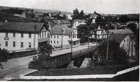
In the years between 1900 and 1903, the area around the Main Street Bridge over Trout Creek underwent a complete redevelopment. This coincided with a building spree throughout Slatington. The area in and around the Main Street bridge saw several new construction projects.
- a new Main Street Bridge across Trout Creek (aka Big Trout Run)
- the Slatington News Building
- the Slatington Baptist Church (on the southwest corner of Main and Second Streets)
- the house built by Silas Benjamin Costenbader at 435 Main Street. This later became known as the Muschlitz house.
- the Crystal Knitting Mill, just northwest of the bridge
- the Slatington Gas Company, just northwest of the Crystal Knitting Mill
- the Alfred Kern house at 404 Main Street at the foot of the bridge (on the northwest corner of Main and Diamond Streets)
These new buildings complemented some buildings that already existed.
- the Henry Kuntz house at 370 Main Street (on the northeast corner of Main and Diamond Streets)
- Kern's grist mill (just south of the bridge)
- Kern's saw mill (just north of the bridge)
- Rice's block, part of which became the Citizens National Bank (opened 1902) at 506 Main Street (on the northwest corner of Main and Second Streets)
- the Kuntz/Costenbader house at 446 Main Street (on the northeast corner of Main and Second Streets)
Eventually, in the immediate vicinity of the bridge several school buildings were built.
- the 1897 first Slatington High School, later known as the Lincoln Elementary School, on Kuntz Alley. It was destroyed by fire on 20 February 1917. After being rebuilt, it reopened in February 1919.
- the 1918 second Slatington High School, later known as the Slatington Junior High, was built on the southeast corner of Main and Second Streets. The “old” public school building had previously occupied this site.
- Smith Hall, the school gymnasium, basketball court and multi-purpose building, opened in 1937.
Looking at this section of Slatington today, you would have little idea of how much activity once existed in this area. Here are some aerial photos and a map.
